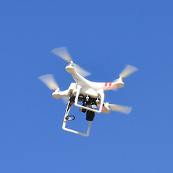
Drones are an exciting new technology that could change how farmers manage their irrigation and could eventually become as ubiquitous as tractors. Drones can collect data that can be used to determine if crops have enough water or find leaks in the irrigation system. Here are some interesting facts about the use of drones on farms.
 The Association for Unmanned Vehicle Systems International estimates that farms will eventually account for an 80% share of the commercial drone market.
Source
The FAA does not currently allow drones for commercial use but there is a proposal under review to change the law and farmers can currently apply for exemptions.
Source
The proposed changes to FAA regulations would require commercial drone operators to obtain a certification which includes passing an exam.
Source
The FAA proposed regulations would restrict flying to daytime only, require that drone operators maintain visual contact with their aircraft at all times, and limit drone altitude to 500 feet.
Source
Drone data can show where crops are healthy and where crops are weak so farmers can make adjustments.
Source
Thermal cameras on drones can be used to detect leaks and determine if crops are getting too much or too little water.
Source
The American Farm Bureau Federation estimates that farmers could see a return on investment of agriculture drones of $12 per acre for corn and $2 to $3 per acre for soybeans and wheat.
Source
According to a study, corn, soybean and wheat farmers could save an estimated $1.3 billion annually by using drones to increase crop yields and reduce input costs.
Source
A drone can zoom down to the square inch and even count each individual plant, which would have previously been very difficult and impractical.
Source
Canada has allowed drone use in agriculture for years.
Source
Drones that could be used by farmers have a wide range of prices from below $1,000 to over $30,000, depending on whether they come with sensors that measure moisture content and plant light reflectivity.
Source
Sensors in drones can also evaluate drainage and track how mature crops are.
Source
A drone’s software can plan a flight path to maximize coverage of a farm’s cropland as well as fly itself from takeoff to landing.
Source
Crop imaging with a manned aircraft can cost $1,000 per hour, while a drone can be bought for less than $1,000.
Source
Drones can be used to survey a crop weekly or daily to create a time-series animation that shows changes or issues that can be acted on.
Source
